Reality capture is a rapidly growing field that is changing the way we view and interact with the physical world of construction. It refers to the process of digitizing the physical world into a 3D model, providing us with a virtual representation of reality.
This can be achieved through various technologies like laser scanning, photogrammetry, and Structure from Motion (SfM). The resulting digital models can be used for a variety of purposes, including architectural design, construction, engineering, and asset management.
One of the most significant advancements in reality capture technology has been the integration of drones. Drones equipped with cameras and other sensors can capture high-resolution images and data from previously inaccessible locations, providing users with an unprecedented level of detail and accuracy. In this blog, we will delve into the role of drones in reality capture and the many benefits they provide.
The use of drones, in reality capture, provides additional views because they can reach locations that would otherwise be difficult or dangerous for humans to access, such as the top of a tall building or remote construction sites. This reduces the need for numerous site visits to the site and the need to have equipment hoisted for longer periods of time.
Drones can capture images from multiple angles, providing a more comprehensive view of the subject. This results in a more accurate 3D model, with a greater level of detail. For example, a drone can capture images from various elevations and angles, giving us a complete view of a building’s facade, roof, and surrounding area.
Drones can also cover large areas in a relatively short amount of time. This makes them ideal for capturing data in large construction sites. Progress assessment can be done within a shorter time than normal, providing valuable information that can be used to make decisions about the next steps in the construction process.
This enables project teams to stay connected, and monitor progress, weather, deliveries and other crucial aspects. The use of drones streamlined construction projects and provided efficient and convenient ways for teams to monitor their work. This also leads to significant cost savings for construction projects, as well as an increase in productivity and accuracy.
For example, a large construction site that would have taken several days to survey using traditional methods can be completed in a fraction of the time using drones.
Using drones in reality capture also offers increased safety and convenience. Surveying and collecting data in dangerous or inaccessible locations can be risky and time-consuming. However, with drones, this process can be done quickly and safely, reducing the risk of injury to personnel.
The integration of drones in reality capture technology has brought about numerous benefits for the construction, architecture, engineering, and asset management industries. The ability to reach inaccessible locations, cover large areas, and provide a comprehensive view of projects has made drones a valuable tool in the field. With the integration of artificial intelligence and machine learning, the potential for even more accurate and detailed models is limitless.
The use of drones in reality capture is only becoming more widespread as the years go by. Companies that embrace this technology and incorporate it into their processes will find themselves at a significant advantage. They will be able to streamline their work, reduce costs, and deliver more accurate and comprehensive data.
In the future, we can expect to see even more advanced drones equipped with a wide range of sensors and technologies, providing us with even more detailed and accurate models.
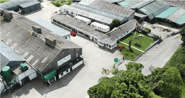
As a software company, one of the most exciting aspects of our work is that we get to experiment with the latest technology that can contribute to transforming the AEC industry, such as the use of drones. Recently, our team had the opportunity to map a large logistics centre using drones for site monitoring and reality capture.
We provided a full-service of drone view with capabilities such as a detailed representation of the construction site and surrounding area. From there, our customers were able to assess the state of a construction site down to the finest details, crosscheck the current condition of the site versus the planning, easily switch between the 3D model and the live Evercam camera view and also perform a safer and quicker inspection
While aerial imagery has been around for a while, it often falls short in the construction industry due to the limitations of static photos which can be outdated and don’t capture data like Google Earth. However, by combining advanced drone features we can capture a current, comprehensive look at a site and gather a large amount of data.
The technology itself is impressive, but the applications are even more so. From being able to use tools like Evercam’s Drone View to measure distances to creating annotations on models to highlight a piece of information such as restricted areas.
The use of technologies such as these is vastly benefiting the industry allowing users to streamline processes, deliver more accurate information, and provide a comprehensive view of projects.
So, if you’re looking to stay ahead of the curve and make the most of your construction projects, consider incorporating drones into your reality capture process. With their versatility, efficiency, and accuracy, drones are the key to unlocking the full potential of site monitoring of your construction projects. Reach out for a demo on how the Drone View can be of use to your project.